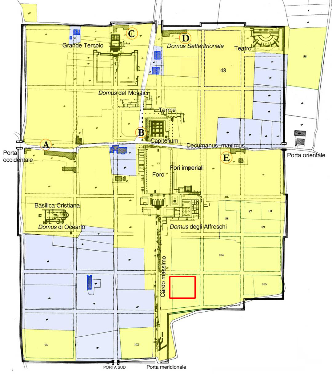
The well-known town of Luna lies on the left bank of the Magra river, set up as a Roman colony in 177 B.C., after the defeat of the Ligurian Apuans
Archaeological excavations carried out since the XVIII century have provided data to reconstruct the layout of the town and its transformations up to the early Middle Ages. Luna’s wealth came from the intensive exploitation of the marble quarries in the Apuan Alps (today the Carrara district): from its harbour system the precious white marble was traded to Ostia and to many other Mediterranean sites. In the Julius-Claudius period Luna reached the acme of its prosperity, evident in its magnificent monuments and decorative furnishings. After a slow, progressive declinestarting from the IV cent. AD, Luna became a strategic town in 552, when it was chosen as the main centre of the Maritima Italorum (Byzantine district). In this phase the ancient Cathedral was fully renewed; it appears to have been dedicated to St. Mary
.jpg) In the following century Luna was occupied by the Lombard King Rotari (643 a.D.) and afterwards was the object of Saracen and, probably, Norman raids. At the same time, the harbour landscape was changing into deserted and swamp areas which were unhealthy because of malaria. Finally, in 1204 the bishop’s throne was moved to Sarzana and Luna became a dead town.
In the following century Luna was occupied by the Lombard King Rotari (643 a.D.) and afterwards was the object of Saracen and, probably, Norman raids. At the same time, the harbour landscape was changing into deserted and swamp areas which were unhealthy because of malaria. Finally, in 1204 the bishop’s throne was moved to Sarzana and Luna became a dead town.
In 2014, archaeological excavations are planned in the Southern part of the town: this area is very interesting because structures most probably connected with one of the main harbours were located outside it. Therefore the Project’s aim is to collect new data about Luna’s intense import-export trade activities.
The Luna excavations will be carried out in collaboration with the Soprintendenza per i Beni archeologici della Liguria, as teacher training courses for students of Pisa University, including Erasmus students.
The excavation trench is located in the area immediately East of the Kardo Maximus, near the Eastern Gate (Porta a Mare).
The 2014-2016 campaigns brought to light a complex formed of at least 7 rooms, which appear to have been divided on a functional basis. The rooms to the South belonged to a domus, while the northern rooms had a productive/artisanal function. All the structures date from the early 1st cent BC up to the second half of the 6th cent./the late 7th cent. AD, when they were progressively abandoned.
Regarding the domus, among others, two rooms respectively paved in opus scutulatum (atrium) and white/black mosaics (tablinum?) have been brought to the light. The latter has, as the central subject, a geometric pattern having alternate white and black flower petals. The outer edge is decorated with a meander motif; moreover, more to the West, a lozenge pattern most probably indicated the passage between two different rooms.
In the early Imperial Age, the northern sector appears to have been built for artisanal purposes: a round basin, with a diameter of about 1,40 m, was constructed, floored with cocciopesto, having a drainin ceramic pipes (tubuli) which discharged into a quadrangular built-in basin, whose base consisted of marble slabs. At the moment we are not sure what activities were carried out in this sector, with due caution we can hypothesize it was a fullonica.
In the course of the centuries, and above all in the late Ancient Age, all the rooms of the complex underwent restoration, changes of use (for example a well was constructed in the domus area), dump deposits and destruction. Nevertheless, commercial activities in the area continued until the end of the 7th cent., as is proved by the numerous late Roman finds (above all amphorae and pottery) from the entire Mediterranean Basin.
See: S. Menchelli, P. Sangriso, S. Genovesi, Luni: le campagne 2014-2015 nel settore sud-orientale della città. In: Dall’Appennino a Luni. Tra età romana e medioevo. Atti Giornata di Studio Berceto 2015, (S.Lusuardi Siena, G. Le Grottaglie Eds.), Centro Studi Lunensi, Quaderni 10, n.s., p. 101-124.
